|
| Hon.Paias Wingti, Governor for Western Highlands Province |
Showing posts with label Western Highlands Province. Show all posts
Showing posts with label Western Highlands Province. Show all posts
Saturday, 13 March 2021
Tuesday, 28 July 2020
Should the Apex of Mountain Hagen(Mountain Mul) be one of the Tourist Attractive Destinations in Papua New Guinea?
Do you think that the Apex(top) of Mountain Hagen Range is one of the greatest potential Tourist Attractive Destinations in Papua New Guinea? If your response to this critical question is NO, it is not a tourist attractive destination amongst other places in Papua New Guinea(PNG) or YES it is a potential tourists attractive destinations in PNG amongst others then you are correct at either of your response as the way you see it with your own opinion. There are no correct or wrong answers to the question asked here. But you think about it. Give your mind some reasoning and you should come up with some interesting ideas around it.
There may be literatures or descriptions about fascinating events, cultures and places within and around Mount Hagen city. Some people write about the beautiful Mount Hagen Main Market known for the varieties of food. Others write about cultures and the famous Mount Hagen Cultural Show which is hosted almost every year. Others interestingly explains the formation of the Mountain Hagen (Mul) Range and extinct volcano and its resulting fertile land of Wahgi Valley by National geologists in the likes of Koiti Mel et al. Others describe how beautiful the apex of Mount Hagen Range.
The online Wikipedia on the other hand gives some factual statistics about Mount Hagen of which many Western Highlanders boast about and take pride in their God given land and home.
Amongst other lists of interesting tourist attracting destinations or significant events in Western Highlands Province, below are the current tourist attracting destinations but not limited to others.
People who have visited the place or those who are told by ancestors about the two lakes do know the common myths of the two lakes. There are few behavioural descriptions about two lakes at the top of the Mountain Range.There could be many descriptive articles in this regard but what was fascinating to the author of this article was this particular facebook post by Alfred Kik based on Manuel Jacob Nui's photo of one of the lakes and it is quoted here: 'There are two big lakes found at the peak of Mt Hagen (3,778 m (12,395 ft)). In Melpa language, the one in this photo is called Num Pombra (means 'dark lake') while the other is known as Num Kundul (‘red/light lake'). There is an interesting myth about the lakes. The dark lake is always 'friendly'. Its perfect blue-sky reflection in crystal clear water and the welcoming surface waves with snow-like bubbles will make you feel like staying there forever. The red lake with its gloomy appearance always scares people and/or increases limnophobia. People are discouraged to get close to the lake or they shall never return.'
The author of this article never seen the lakes but it is on the wish list to visit this place one day and hope some of the viewers of this article who also dream of visiting the lakes too and experience the beauty.
Almost every year, most locals live around the area make plans in group and visit the apex of the Mountain Hagen Range. There are very interesting stories you can tell if you ever visited this place. Some of the obvious reasons are for sightseeing purposes which include but not limited to:
There may be literatures or descriptions about fascinating events, cultures and places within and around Mount Hagen city. Some people write about the beautiful Mount Hagen Main Market known for the varieties of food. Others write about cultures and the famous Mount Hagen Cultural Show which is hosted almost every year. Others interestingly explains the formation of the Mountain Hagen (Mul) Range and extinct volcano and its resulting fertile land of Wahgi Valley by National geologists in the likes of Koiti Mel et al. Others describe how beautiful the apex of Mount Hagen Range.
The online Wikipedia on the other hand gives some factual statistics about Mount Hagen of which many Western Highlanders boast about and take pride in their God given land and home.
Amongst other lists of interesting tourist attracting destinations or significant events in Western Highlands Province, below are the current tourist attracting destinations but not limited to others.
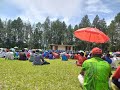
- The Famous Mount Hagen Cultural Show.
- Baiyer Zoo
- Mount Rondon Ridge
- Variety of fruits and vegetables at Mount Hagen Main Market.
- Various Hotels
These tourist destinations are either promoted by Papua New Guinea Tourism Promotion Authority or by individuals who provide online information in these regards or by any other means. Based on such information, tourists decide when and where to visit.
Amongst the current tourist destinations within Western Highlands Province mentioned above, there is this beautiful Mountain Hagen Range Apex locally known as Mul Kui is one of the best and most attractive tourist destinations in Western Highlands Province which is least realised and least promoted at certain levels. What makes you think that this is possible or otherwise?
To clear some doubts, there were few international tourists especially missionaries who have visited the top of Mountain Hagen Range. In the case of local tourists, those tribes (Nenga, Mele, Munjuka, Kumdi, Komka, Kutump, ) living at the foot of Mount Hagen (Mul) Range and those nearby tribes visit the apex of mountain range almost every year on fine whether conditions and on school holidays as most school kids love to visit the top of Mul Kui.
What really fascinates them is to reach the apex(top) of Mountain Hagen (Mul) Range. Not only that, but also there are various reasons of which the obvious objective amongst others is to see the two mysterious lakes at the top of the mountain range. The locals who have been there describe the reactions of both lakes when people visit. Other locals wish to visit but they never visit and it has been on their wish list to visit the two lakes.
 |
| ( Clear Lake at apex of Mt.Hagen RangePhoto courtesy: Manuel Jacob Nui -) |
People who have visited the place or those who are told by ancestors about the two lakes do know the common myths of the two lakes. There are few behavioural descriptions about two lakes at the top of the Mountain Range.There could be many descriptive articles in this regard but what was fascinating to the author of this article was this particular facebook post by Alfred Kik based on Manuel Jacob Nui's photo of one of the lakes and it is quoted here: 'There are two big lakes found at the peak of Mt Hagen (3,778 m (12,395 ft)). In Melpa language, the one in this photo is called Num Pombra (means 'dark lake') while the other is known as Num Kundul (‘red/light lake'). There is an interesting myth about the lakes. The dark lake is always 'friendly'. Its perfect blue-sky reflection in crystal clear water and the welcoming surface waves with snow-like bubbles will make you feel like staying there forever. The red lake with its gloomy appearance always scares people and/or increases limnophobia. People are discouraged to get close to the lake or they shall never return.'
The author of this article never seen the lakes but it is on the wish list to visit this place one day and hope some of the viewers of this article who also dream of visiting the lakes too and experience the beauty.
Almost every year, most locals live around the area make plans in group and visit the apex of the Mountain Hagen Range. There are very interesting stories you can tell if you ever visited this place. Some of the obvious reasons are for sightseeing purposes which include but not limited to:
- The Fantastic sightseeing on the lookout at the apex where you have a clear view of Western Highlands Province , Jiwaka Province and off course Wapenamanda at the background. It is really a breathtaking view and off course a stress relieving view many would agree.
- The interesting evidence of the springs that forms the headwaters of Famous Baiyer River/Lai and Wahgi River.
- Enjoy the comfort of short lawns and relax at the top taking rest or having lunch while enjoying the view with sounds of colorful birds singing and enjoying the morning dews on unique and ever blooming varieties of flowers that a naturally grown around many smaller lakes at the apex. The ever blooming flowers are welcoming and will make you think that you are in a blessed area and wish for permanent residence but the cool mountain breeze will make you feel cold and shivering that will chase you away.
- The wonderful experience and witnessing or proofing the myths of the two mysterious lakes at the apex of Mount Hagen (range).
These are the reasons many people are so much interested to visit the top of the mountain range and the interest keep building and expanding for the people who have already been there and those who are planning to be there too. This clearly shows that, this place has a very high potential of attracting both local and international tourists. It looks feasible to develop this place and promote this place to attract tourists and this place will be one of those fascinating tourist destinations in Papua New Guinea just like Mount Wilhelm, Mount Giluwe, Mount Tavuvur etc..
Finally, do you agree that the Apex of Mount Hagen (Mul) Range will be a fantastic tourist destination in the Future for both Nationals and Internationals? Leave you comments here.....
Wednesday, 4 April 2018
Bukapena Landowners Protest on Compensation Payment
The Legitimate Landowners of Bukapena Government Station in Mul District of Western Highlands Province have protested and call the Department of Lands and Physical Planning to put on hold to the process of gazetted compensation payment.
The protest began upon the publication of the gazetted payment for Bukapena Government Station. The landowners representative, Mr.Jacob Hon call on the Department of Lands and Physical Planning to do a proper investigation prior to payment processing. There was no proper valuation done and no landowner consultation.
If the payment is to be made for Bukapena Station then it has to be made through the Nenga Andakel Clan and no any other clan,tribe or individual.
The aggressive landowners have blocked the Bukapena Primary School gate and the Health Center and District office were interrupted by the disgruntled Nenga Andakel Clan who are the legitimate landowners of the Bukapena Government Town. They said if the payment is made to other people who have claimed it then all the Government station is mostly likely be affected.
 |
| News Article on Post Courier Dated March 28,2018 |
 |
| Disgruntled Landowners of Bukapena Goverment Station, The Nenga Andakel Clan members |
Wednesday, 28 March 2018
BUKAPENA GOVERNMENT STATION (TOWNSHIP) IN MUL DISTRICT OF WESTERN HIGHLANDS PROVINCE.
The
Bukapena Village alone hosts six (6) Government Services and the legitimate
landowners are the Nenga Andakel. There was no ILG ever been registered in the
name of Bukapena within the Lands Department and if any ILG lodged then it is
without proper landowner consultation and no proper land investigation is done.
The
only six (6) government services established during colonial era are:
- · Bukapena Community School (Currently Known as Bukapena Primary School).
- · Mul District Headquarter & Mul LLG Council Chamber
- · Bukapena Health Centre
- · Bukapena Rural Police Station
- · Bukapena DPI
- · Bukapena Council Market.
It
is also known that during the colonial era, my forefathers were smart enough to
bring all the vital government services
to my village without fair market value of land during compulsory customary
land acquisition. Only the Nenga Andakel Clan sacrificed their customary land
to allow for government services to be constructed and they are the legitimate
landowners ever since and they will be for unending generations. If any claims
or compensations are to be paid to Bukapena Government Station then it has to
be paid to the Nenga Andakel Clan and not any other clan, tribes or individual.
On
behalf of the Nenga Andakel Clan members and leaders, Mr.Jacob Hon Derk who is
the Former Councillor and Clan Leader expressed the Nenga Andakel Clan’s grievances
to the Department of Lands and Physical Planning on Post Courier dated 28th
March 2018. This issue arose upon a published
gazetted compensation payment for the Bukapena Station which was claimed by
unknown clan, tribe or individual in the Mul District of Western Highlands
Province.
Mr.Hon
strongly objected and boldly requested Department of Lands and Physical
Planning to stop the payment process of the gazetted land compensation payment
for Portions 9,409,391,254 and 1256c or whatever latest updated portion numbers
of Bukapena and further request the Department of Lands & Physical Planning
to further investigate on the ground the legitimate landowners of Bukapena to
avoid entertaining the so called paper landowners of unknown creatures in Port
Moresby.
Mr.Hon
said that, Failure to stop the payment process will result in legal action(s)
against these claims and he is off the view that further disturbances to the
Government Services will be minimised at this level if payment process is
stopped and allow proper land investigation to proceed thereon.
Mr.Hon
said copies of written objections were lodged with the Department of Lands and
Physical Planning via the Acting Secretary’s Office the objection was registered for deliberation.
 |
| Estimated Clan Boundaries of Nenga Oiyamp |
Wednesday, 20 September 2017
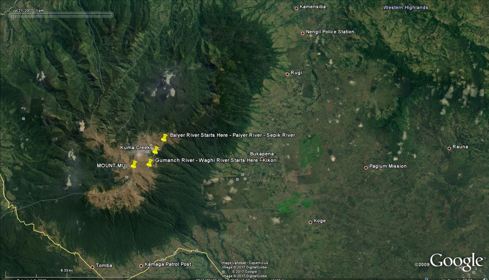
Waghi River (Gumanch River)
The some of the headwaters that springs out from Mount Mul are: Yuu, Wuip, Rurulg,Kuma, Gumanch, Paiyer, Ambulg,Kintip,Petaka, Kumbula and few other tributaries to Baiyer River (Paiyer).
Kuma Creek starts at the opposite and west of Paiyer River. Only one mountain range separates them. Futher to Kuma creek is Gumanch which further West of Kuma. Kuma and Gumanch meet together at Wekmulg near Kwip and thereafter the river is known as Gumanch until it meets Waghi River. The Waghi River then flows collectively with other tributaries along Western Highlands Province, Jiwaka Province, Simbu Province and Gulf Province that eventually known to be Rurari River that meets the sea at Gulf of Papua.
Kuma Creek starts at the opposite and west of Paiyer River. Only one mountain range separates them. Futher to Kuma creek is Gumanch which further West of Kuma. Kuma and Gumanch meet together at Wekmulg near Kwip and thereafter the river is known as Gumanch until it meets Waghi River. The Waghi River then flows collectively with other tributaries along Western Highlands Province, Jiwaka Province, Simbu Province and Gulf Province that eventually known to be Rurari River that meets the sea at Gulf of Papua.
 |
| Google Map of Gumanch River Starts |
Tuesday, 19 September 2017
Baiyer River (Paiyer River - Wara Paiyer) in Western Highlands Province, PNG
Baiyer River is one of the largest River in the province. It comes out from a cluster of boulders as a little spring located right at the top of Mount Mul (Mul Komonga). The spot is decorated with grasses and colourful flowers that spreads the top of the mountain. The starting name of the creek is known as Paiyer which eventually known along certain kilometres from Mul - Baiyer and then it is known as Baiyer River from Baiyer to Lumusa and extends further to Lai and Sepkik River.
On the other side of the same mountain range is a spring known as Kuma. Kuma is separated by another mountain range and there comes out the Gumanch River. Kuma and Gumanch meet together at Wekmulg near Kwip and thereafter the river is known as Gumanch until it meets Waghi River.
There are also several varied coloured pools that naturally exist just at the side of the mountain top of Mul.
The Paiyer River flows along the thick forest of Mul until it reaches first village known as Marapana then followed by Tagla and Keiya Ralg. It then follows further down and meet tributaries known as Pup and Kela at Wara Village. It flows along the tribes of Mele and Nenga. The next known tributaries are Ramund, Kintip, Petaka, Kumbula, Kunim, Hurmil that extend to the tribe of Kumdi along Rugli and Nengil, Boor, Kombolopa.
As the tributaries increase in numbers along its gravitational flow, the size and current of the river increases. At the head waters, it is easy to cross over but at certain kilometres after Bukapena Village, it is quite a challenge to cross the Paiyer river easily.
The Paiyer River reaches miles along the Mul Baiyer and Lumusa. The name Paiyer River changes to Baiyer River once it reaches Baiyer and Lumusa Districts.
The next tribes that the Baiyer River reaches are Enga Kumbu, Enga Maip, Ukuni, Kopi, K-Witi and several other tribes of Enga Baiyer along Kaldeta, Rupanda, Baiyer Zoo, Kumbris etc.
The Baiyer River further extends North East and meets Lai River, Muka River along Koles, Wadji, Tamo in the East Sepik Province, Sipisipi, Bun, Biwat and eventually meets the Sepik River at Arangumam Moim and Kambrindo Villages near Angoram in the East Sepik Province of Papua New Guinea.
Baiyer River starts at Mount Mul (Mt.Hagen), in the Mul District of Western Highlands Province, PNG. Likewise, Purari River starts from Mount Mul.
 |
| Map of Mount Mul |
Friday, 28 April 2017
Name Change of Mount Mul to Mount Hagen
Mount Hagen City is not the original name known by the forefathers of the Western Highlands Province and PNG at large. Mount Hagen was previously known as Lgomis Town or Lgomis and Mountain Hagen as Mountain Mul (Mul Komonga).
The Lgomis name and Mount Mul (Mul Komongo) were both changed to Mount Hagen at the same time when the German Colonial Officer Curt von Hagen (1859-1897) first step foot in Lgomis in 1960s. Curt von Hagen came to Western Highlands as a Tourist to the First Cultural Show in 1960 in the Western Highlands Province and the Western Highlanders were psyched up to change both names: Mount Mul and 'Lgomis town' to Mount Hagen after Curt von Hagen. Actually the Mountain was given the name Mountain Hagen and the third city of Papua New Guinea adopted the Mountain's name.
Before that, the Goroka Cultural show was the prior culteral show before Mount Hagen Cultural Show. The First Mount Hagen Cultural Show brought one name that consolidated two names which the generation of today know only the consolidated name and only few know the old names (Mul Komonga and Lgomis)
.
The Lgomis name and Mount Mul (Mul Komongo) were both changed to Mount Hagen at the same time when the German Colonial Officer Curt von Hagen (1859-1897) first step foot in Lgomis in 1960s. Curt von Hagen came to Western Highlands as a Tourist to the First Cultural Show in 1960 in the Western Highlands Province and the Western Highlanders were psyched up to change both names: Mount Mul and 'Lgomis town' to Mount Hagen after Curt von Hagen. Actually the Mountain was given the name Mountain Hagen and the third city of Papua New Guinea adopted the Mountain's name.
Before that, the Goroka Cultural show was the prior culteral show before Mount Hagen Cultural Show. The First Mount Hagen Cultural Show brought one name that consolidated two names which the generation of today know only the consolidated name and only few know the old names (Mul Komonga and Lgomis)
 |
| Mount Mul |
Monday, 17 April 2017
Mount Mul (Hagen) Hosts Headwaters of two Major Rivers in PNG, The Purari River and the Sepik River.
Mount Mul seem to be the center of Papua New Guinea. Mount Mul hosts two headwaters that contribute to the two biggest rivers in PNG, namely: Purari River and Sepik River. The headwaters that contribute are: Gumanch and Nebilyer -(Trulg, Yu, Waip) contribute to Purari River and Paiyer with other tributaries contribute to Baiyer River that joins with Sepik River.
The next article will be in detail on which places the rivers (Purari River and Baiyer River) touches until it ends up in the sea.

The next article will be in detail on which places the rivers (Purari River and Baiyer River) touches until it ends up in the sea.
Wednesday, 12 April 2017
MOUNT MUL
Mount Mul is the third highest Mountain in Papua New Guinea (PNG) and it is located in the Western Highlands Province. It is commonly known as Mount Hagen. The Original and natural name of Mount Hagen is Mount Mul. The locals: Nenga, Munjika, Komka, Kutump, Mele, Ramdi, Kumdi tribes use to call in the Melpa Language of Western Highlands as MUL KOMONGA. The name MUL is in the local language which means something that exist during the creation.
The name Mul was somehow changed to Hagen and the mountain is currently known as Mount Hagen. The Mountain was named after a German Colonial Officer Curt von Hagen (1859-1897). The third bigest city in Papua New Guinea is given the name of this Mountain.
If it was not Curt von Hagen then the name should remain natural as MOUNTAIN MUL and probably the city could have been given the same name or otherwise.
When?How?Why?What?Who? Actually involved in this name change of the Naturally Known MUL is the next articles.
 |
| Mount Mul Range |