Description of Beautiful Places and people around world. Enjoy the discoveries!!

Wednesday, 29 November 2017

Beatiful Sanaroa Island of Papua New Guinea

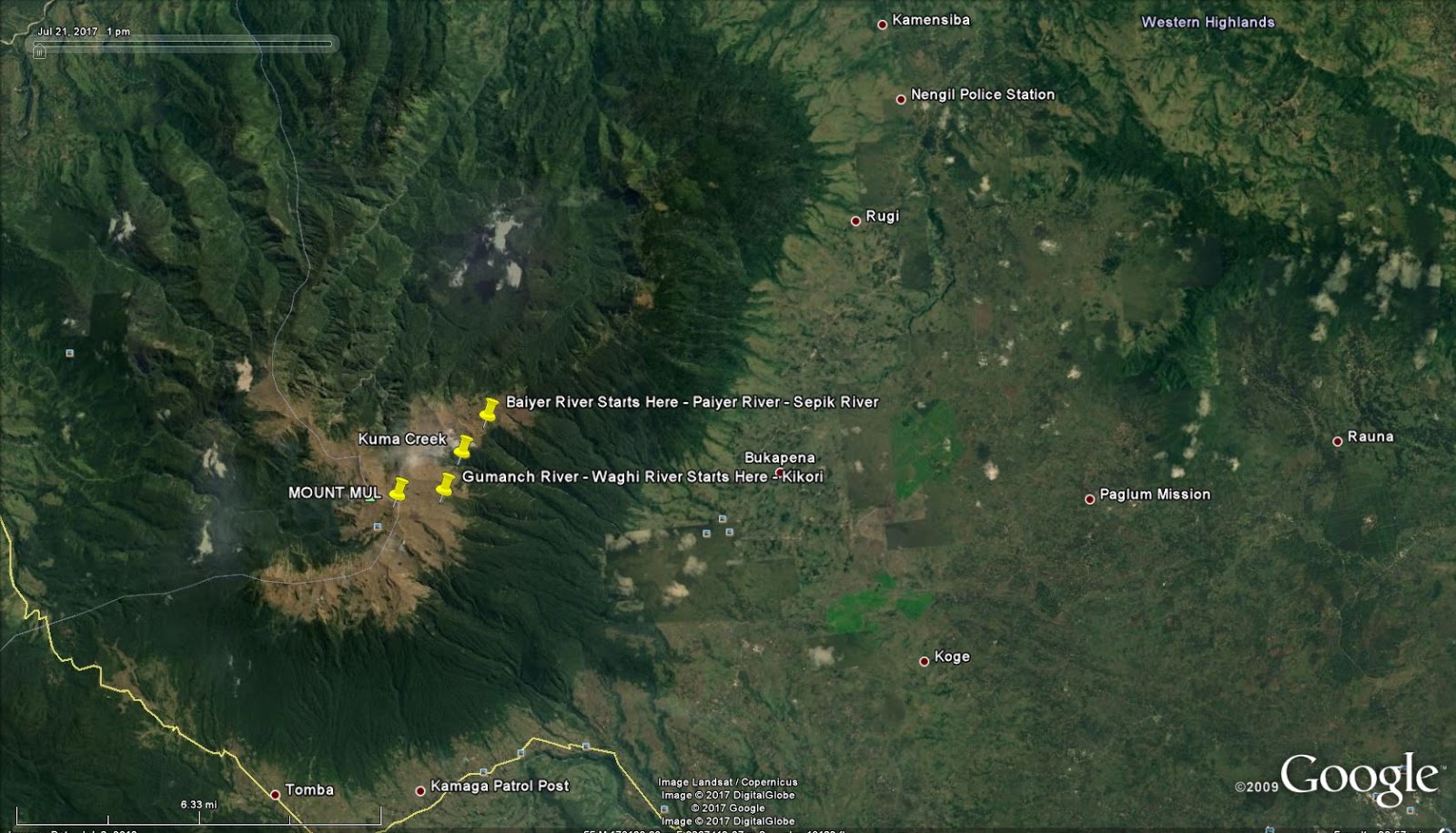
The Beautiful Sanaroa Island is located at just next to Ferguson Island in the Milne Bay Province of Papua New Guinea. Before you reach this Island , you have to go through East Cape from Alotau which is locate at the very tip of the PNG mainland
and you have to pass through Normanby Island and Ferguson Island.

You can either reach via Sehulea Station along Wayoko or via the passage between Ferguson and Normanby Islands. Through the passage you will definitely pass along Esaala and Dobu Island.

The island's cloudy white reef at the sea floor which dictates the colour of the sea. The colour of the see changes from dark -blue to sky-blue, green to clear. It is also a best breeding ground for tuna fish which reflects in locals catch fish at anytime when they go fishing within the coastline.

The island itself is so beautiful when you just go along the coast. The mangroves and the plants along the coast with the background of the grassland hills provides a wonderful view ever.

The clans that live in this island include but not limited to Gewale Clan, Yowana Clan , etc. and the island has a primary school which is known as Sanaroa Primary School. Government service is a great need for the people in villages. One of the common village visited by the author is Udaudana Village which lies towards East of Ferguson Island.
Sanaroa Island Via East Cape
Share:

Wednesday, 20 September 2017

Waghi River (Gumanch River)

The some of the headwaters that springs out from Mount Mul are: Yuu, Wuip, Rurulg,Kuma, Gumanch, Paiyer, Ambulg,Kintip,Petaka, Kumbula and few other tributaries to Baiyer River (Paiyer).

Kuma Creek starts at  the opposite and west of Paiyer River. Only one mountain range separates them. Futher to Kuma creek is Gumanch which further West of Kuma. Kuma and Gumanch meet together at Wekmulg near Kwip and thereafter the river is known as Gumanch until it meets Waghi River. The Waghi River then flows collectively with other tributaries along Western Highlands Province, Jiwaka Province, Simbu Province and Gulf Province that eventually known to be Rurari River that meets the sea at Gulf of Papua.
Google Map of Gumanch River Starts 

Share:

Tuesday, 19 September 2017

Baiyer River (Paiyer River - Wara Paiyer) in Western Highlands Province, PNG

Baiyer River is one of the largest River in the province. It comes out from a cluster of boulders as a little spring located right at the top of Mount Mul (Mul Komonga). The spot is decorated with grasses and colourful flowers that spreads the top of the mountain. The starting name of the creek is known as Paiyer which eventually known along certain kilometres from Mul - Baiyer and then it is known as Baiyer River from Baiyer to Lumusa and extends further to Lai and Sepkik River.

On the other side of the same mountain range is a spring known as Kuma. Kuma is separated by another mountain range and there comes out the Gumanch River. Kuma and Gumanch meet together at Wekmulg near Kwip and thereafter the river is known as Gumanch until it meets Waghi River.

There are also several varied coloured pools that  naturally exist just at the side of the mountain top of Mul.

The Paiyer River flows along the thick forest of Mul until it reaches first village known as Marapana then followed by Tagla and Keiya Ralg. It then follows further down and meet tributaries known as Pup and Kela at Wara Village. It flows along the tribes of Mele and Nenga. The next known tributaries are Ramund, Kintip, Petaka, Kumbula, Kunim, Hurmil that extend to the tribe of Kumdi along Rugli and Nengil, Boor, Kombolopa.

As the tributaries increase in numbers along its gravitational flow, the size and current of the river increases. At the head waters, it is easy to cross over but at certain kilometres after Bukapena Village, it is quite a challenge to cross the Paiyer river easily.

The Paiyer River reaches  miles along the Mul Baiyer and Lumusa. The name Paiyer River changes to Baiyer River once it reaches Baiyer and Lumusa Districts.

The next tribes that the Baiyer River reaches are Enga Kumbu, Enga Maip, Ukuni, Kopi, K-Witi and several other tribes of Enga Baiyer along Kaldeta, Rupanda, Baiyer Zoo, Kumbris etc.

The Baiyer River further extends North East and meets Lai River, Muka River along  Koles, Wadji, Tamo in the East Sepik Province, Sipisipi, Bun, Biwat and eventually meets the Sepik River at Arangumam Moim and Kambrindo Villages near Angoram in the East Sepik Province of Papua New Guinea.

Baiyer River starts at Mount Mul (Mt.Hagen), in the Mul District of Western Highlands Province, PNG. Likewise, Purari River starts from Mount Mul.
Map of Mount Mul
Share:

Friday, 28 April 2017

Name Change of Mount Mul to Mount Hagen

Mount Hagen City is not the original name known by the forefathers of the Western Highlands Province and PNG at large. Mount Hagen was previously known as Lgomis  Town or Lgomis and Mountain Hagen as Mountain Mul (Mul Komonga).

The Lgomis name and Mount Mul (Mul Komongo) were both changed to Mount Hagen at the same time when the German Colonial Officer Curt von Hagen (1859-1897) first step foot in Lgomis in 1960s. Curt von Hagen came to Western Highlands as a Tourist to the First Cultural Show in 1960 in the Western Highlands Province and the Western Highlanders were psyched up to change both names: Mount Mul and 'Lgomis town'  to Mount Hagen after Curt von Hagen. Actually the Mountain was given the name Mountain Hagen and the third city of Papua New Guinea adopted the Mountain's name.

Before that, the Goroka Cultural show was the prior culteral show before Mount Hagen Cultural Show. The First Mount Hagen Cultural Show brought one name that consolidated two names which the generation of today know only the consolidated name and only few know the old names (Mul Komonga and Lgomis)
Mount Mul
.
Share:

Monday, 17 April 2017

Mount Mul (Hagen) Hosts Headwaters of two Major Rivers in PNG, The Purari River and the Sepik River.

Mount Mul seem to be the center of Papua New Guinea. Mount Mul hosts two headwaters that contribute to the two biggest rivers in PNG, namely: Purari River and Sepik River. The headwaters that contribute are: Gumanch and Nebilyer -(Trulg, Yu, Waip) contribute to Purari River and Paiyer with other tributaries contribute to Baiyer River that joins with Sepik River.

The next article will be in detail on which places the rivers (Purari River and Baiyer River) touches until it ends up in the sea.


Share:

Translate

Travellers Guides

Description of Beautiful Places and people around world. Enjoy your discoveries!!

Featured post

Hiking at Mt.Limori Yama at Minami-ku, Fukuoka Prefecture, Japan

 Hiking at Limori Yama at Minami-ku, Fukuoka Prefecture is a lot more fun. There are several routes that gets you there. Going up the hill i...